0 Comments
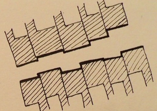
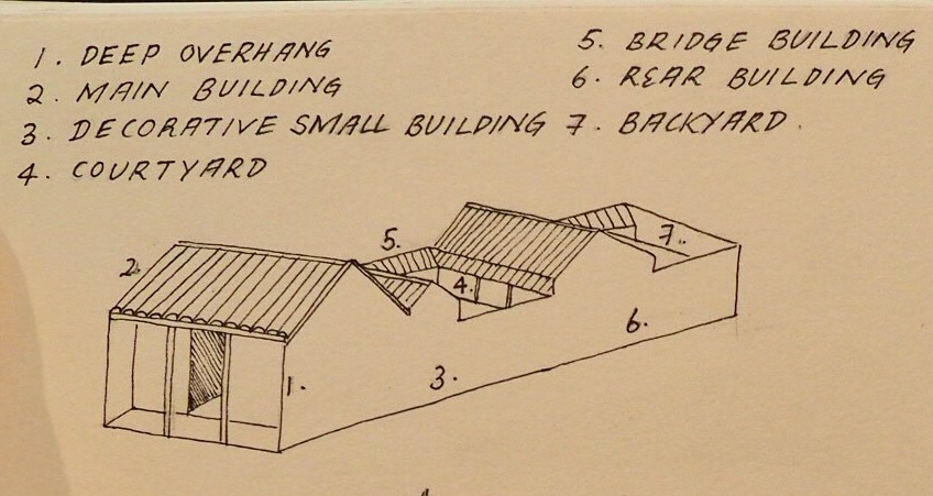
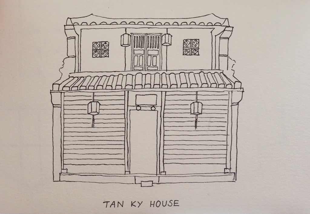
Hoi an is an ancient port town with over 1000 years of history. The town has been granted Unesco heritage status, with over 800 buildings preserved in the Old town. This is significant in that entire streetscapes have been preserved - as you cross over into the Old town district it is almost as if you've stepped back in time into the 17th-18th century, surrounded by bright yellow row houses covered in greenery. Once a prosperous centre for trade, Hoi an was once one of South East Asia's major ports, with Chinese, Japanese, Dutch, Portuguese, Spanish, Indian, and American ships stopping in to ply their wares. In particular, the Chinese and Japanese merchants made their mark, spending the spring months in the town and occupying water front houses to use as living quarters and warehouses. Many of these houses still bear elements of Chinese and Japanese architectural influence. The Japanese ceased coming to Hoi an during the 'Sasoku' period of isolation, but the Chinese continued to come, settling in communities and building assembly halls known as 'Hoi quan', as a place for meetings social gatherings. Many of the buildings in the Old quarter have been preserved as living museums and are open to the public, several of which we visited during our time in Hoi an. Tan Ky House Tan Ky house is over 200 years old, having housed seven generations of the same Vietnamese family. It is a typical two-storey merchant's house.
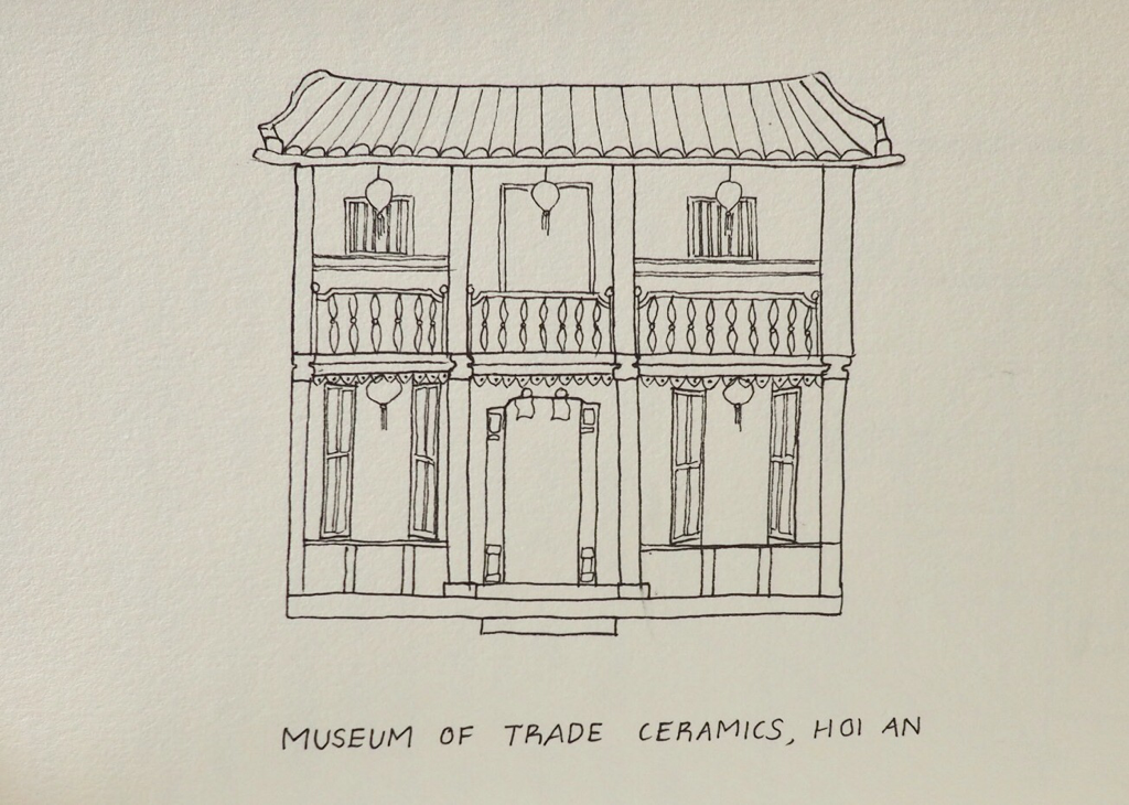
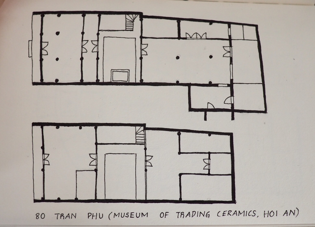
Museum of Trade Ceramics, Hoi an The Museum of Trading ceramics is housed within a traditional merchant's house, formerly known as '80 Tran Phu'. The museum collection comprises of a wide selection of Japanese, Chinese, and Vietnamese ceramics discovered during archaeological excavations in the local area. The museum offers cultural and historical insights into foreign relationships and trade in Hoi an while offering a glimpse into the daily life of a merchant.
Housing type: Haveli Location: Mandawa, Shekawati The city of Mandawa is located in the Jhunjhunnu district of Rajasthan, 190km north of Jodhpur. It is known as the 'open gallery' of Rajasthan due to the beautiful frescoes that adorn the city's houses. These houses were mainly built between the 17th and 19th century by Mewari merchants. Climate: Mandawa is considered to be a Hot semi-arid climate, falling within the BSh category according to the Koppen-Geiger climate classification. A large portion of Outback Australia also lies within the Hot semi-arid classification. Mandawa is located in the Thar desert, experiencing a harsh, extreme climate. The temperature ranges from 0-50 degrees celsius. In summer the region experiences hot waves of air known as 'loo', while sandstorms are a common occurrence. Siting and orientation The city consists of a dense settlement plan, with free standing dwellings closely situated to form narrow streets. This planning encourages mutual shading of adjacent buildings, reducing the area of exposed surfaces to the sun. The narrow streets are overshadowed by the tall buildings during the day, creating a shaded thoroughfare and reducing the ambient temperature surrounding the buildings. Streets are oriented North-South with tall buildings either side, forming a loose grid pattern. Most are oriented with their long side facing North, minimising East-West exposure. Plan and internal layout: There is a clear delineation between public and private spaces which is reflected in the planning of the Mandawa haveli. Each haveli usually has two main courtyards- the front courtyard is considered public space, where men would conduct their business, while the second inner courtyard pertains a semi-private space reserved for women to relax and carry out their daily work. The rooms surrounding this inner courtyard are known as the 'zenana' - the strictly private area in which the women of the house live. 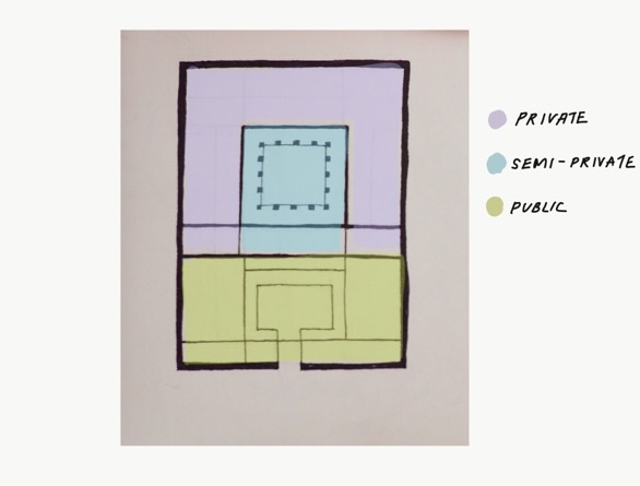 In addition to carrying out daily activities, the courtyard was also the centre of religious and social gatherings. The inner courtyard is surrounded by high building mass leading to induced ventilation, while also providing the interior with natural daylight. There is generally only one entry/exit into the haveli, ensuring both security and privacy. The area surrounding outer courtyard, or 'chowk' generally consists of the reception area (bathaik), goods store, and meeting spaces, while the inner private courtyard was comprised of the kitchen, store room, and bedrooms. The living rooms were usually located on the first floor. 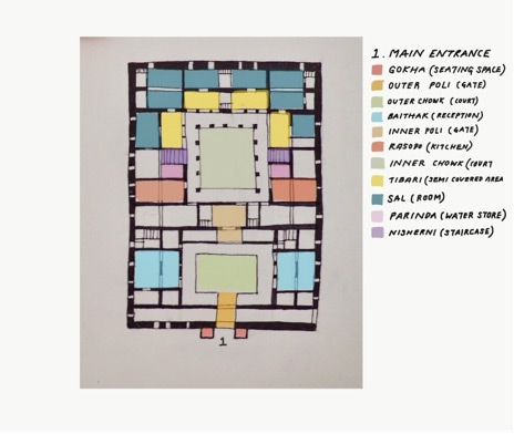 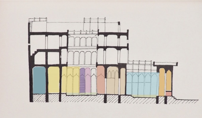 Walls
Walls are generally between 450-1000mm in thickness, providing high thermal mass, and increasing the time lag required for heat to enter the building. This ensures that the interior is kept cool during the day. Walls are generally constructed from locally available stone and lime plaster. Roof Most havelis employ a flat style roof consisted of stone slabs jointed with lime mortar. A layer of inverted earthen pots sit atop the stone slab to create an air layer for insulation. These are covered with a layer of lime mortar finished with broken porcelain, to reflect sunlight. Habitable rooms generally have a ceiling height of around 3.5 metres, while temporary/ occasional rooms such as the women's viewing gallery are around 1.8-2.5 metres high. Openings Due to the hot and dusty desert conditions, natural ventilation during the day is undesirable. Therefore , small openings are provided to allow for convective cooling at night time. These are covered by thick wooden shutters which are kept closed throughout the day. All openings are protected by carved stone projections, known as jharokhas. W Jodhpur Mehrangarh Fort is an impressive sight, presiding over the city like a rock hewn monolith, seemingly formed by thousands of years of geological processes rather than built by the hands of men. Its walls, built from the very ground it sits upon, blend seamlessly into the landscape, structure melding into rock. The palace is formed by a network of halls and courtyards, displaying classical elements of Rajasthani architecture including jharokha (overhanging balconies), and jaali (stone lattice screens). After exploring the palace, I walked down to the ramparts of the Fort, offering panoramic views across the Old City. The city is a sea of blue houses - once exclusively the colour of the Brahmin caste, non-Brahmins have now taken up the trend as well. The blocky blue houses seem to mimic the angular form of the Fort on macro scale. I spent the rest of the afternoon exploring the old city market and wandering the backstreets of Jodhpur in search of blue houses. Jaisalmer Jaisalmer Fort rises up from the desert like a massive sandcastle, with the golden city city of Jaisalmer laid out before it. Established in 1156 by clan leader Jaisal, the city remains a living urban centre, with around 3000 people living within its walls. Situated in the fort's main square is the former ruler's Fort palace. After making our way through the palace, we were rewarded with panoramic views of the city. Built from the same yellow sandstone as the Fort, its easy to see how Jaisalmer earned the moniker of 'Golden city'. After visiting the Fort we made our way through the winding streets of Old town to 'Patwon ki Haveli'. The havelis of Jaisalmer show incredible craftsmanship through their intricately carved screens, balconies, and turrets wrought from honey coloured sandstone. Most of these exquisite houses were built by rich merchants during the 18th-20th centuries. One part of Patwon Ki Haveli (It's massive) is open to the public as a museum, set up to demonstrate insights into 19th century life. Khuri We set out the next day for the desert outpost of Khuri located in the Thar desert, around 40km from the Pakistan border. After taking some time to rest in our 'Swiss tent' accommodation, we were met by our trusty camel guides, Ajmer and Nepal. They were both small boys around the age of 7-10 so I wasn't entirely willing to put my faith in them while riding these giant, bumpy beasts, but I didn't have much choice. Ajmer and Nepal lead us to a nearby village where we dismounted and walked among the complex of earthen dhani huts while our camels stopped for a drink. We jumped back on our steeds and they lead us out to the dunes where we stopped to watch the sun set over the desert, one of my favourite moments of the trip. Dagri The next day we set off for Dagri village, home to the family of our tour organiser, Sabu. Sabu's family are farmers, growing crops such as wheat and aniseed. Here we experienced a slower pace of life to what we had been used to for most of our trip through India, mainly left to our own devices. In the afternoon we walked to the local village, and instantly piqued the curiosity of the locals. Being off the beaten track, they don't see many tourists/ westerners in Dagri so we were certainly a novelty. By the time we reached Sabu's uncle's place for a cup of chai, we had gained an entourage of around 20 people. The next morning, Sabu's sister Salu surprised me with an outfit she had sewn for me - traditional Rajasthani clothing consisting of a skirt and tunic with veil. She then proceeded to dress me up and give me a makeover- which I was probably in desperate need of given that I'd been wearing the same few sets of clothes and not having worn makeup for several months! Mandawa Our last stop before venturing back to Delhi was Mandawa, in the Shekawati region, often referred to as the 'open art gallery' of Rajasthan for its spectacularly painted havelis. Our driver Mr. Nanu organised for a local man, Taj, to take me around to see some of the better examples around Mandawa. Firstly we went to Jhunjhunwala haveli, featuring a spectacular gold painted room adjacent to the main courtyard. Apparently over 3kg of gold leaf was used in the process. The next haveli was in a fairly dilapidated state, but I had free reign to explore each of its rooms. Most were in need of attention but there was one room preserved in its original painted glory, not having been exposed to direct sunlight or weather. The last haveli we visited is one of the few to have had its frescoes restored, as none of the structures in Mandawa have any kind of Unesco or heritage listing. The bottom floor had been repainted to its former glory second story retained its original appearance, highlighting the difference made by the passage of time. Each of the havelis shared a common layout, each being double storied and consisting of two separate but interconnected courtyards - originally these were designated as male/ female. Several of the haveli's in Mandawa have been restored and converted into hotels, and we were lucky enough to stay in one of these, the Hotel Heritage Mandawa. Udaipur We arrived in Udaipur late afternoon, just in time for stunning sunset views of the lake city from our haveli roof top terrace. Aashiya haveli is typical of these traditional Indian townhouses/mansions in Udaipur, characterised by a central courtyard which forms the heart of family life. The recently renovated Aashiya haveli has been in the family for 224 years. From the rooftop we have views across the city and Lake Pichola, including the Lake Palace and City Palace. The entire city is medium density, 3-4 storeys, and almost every building has a rooftop (many with restaurants and bars), creating a vibrant, interconnected atmosphere. The following day was the eve of Holi-colour festival. On our way to the City Palace we visited Jagdish temple where women in brightly coloured sarees sold bags of colour. The City Palace courtyard was filled with tables and chairs, and attendants making ready for the royal festivities. The main part of the City Palace is now devoted to a the City Palace museum, allowing you to walk through the former royal quarters, including the Rai Angan (Royal courtyard), Baadi Mahal, and Mor chowk (Peacock courtyard). Walking through the narrow, maze like hallways was slightly disorienting and claustrophobic, especially amongst the throng of local Indian tourists. The palace complex is comprised of a number of palaces interconnected by chowks (courtyards) with zig zagging corridors - it was planned in this way to thwart any potential intruders and it seems as though this system is still effective today. We were treated to celebratory fireworks during dinner and afterwards we went down to check out the local scene at Jagdish temple, which amounted to some kind of Indian boy band/ karaoke dance party. The next day we ventured out into the street, wary of what was in store for us. We hadn't made it far before we were ambushed by a group of local guys who proceeded to smear coloured powder over our clothes and faces. This happened several more times on our way down to the temple. The scene that awaited us was a frenzy of colour, the crowd pulsating to the beat of the drums. We squeezed our way through the crowd to take refuge on the temple steps, a safe vantage point from which to watch the proceedings. After an hour or so, covered head to toe in colour, we retreated back to our haveli to have showers before embarking on our journey to Ranakpur. Ranakpur Ranakpur is renowned for its Jain temple complex, one of the largest and most significant sites for Jainism in India. The Jain temples are markedly different to most of the historical sites we've seen so far in India as there is a compulsory audio guide, and no human guides are allowed inside the temple. As a result of this, it is a rare place of serenity and contemplation. The temple itself is exquisite, a forest of intricately carved white marble columns, individually wrought, so no two are alike. The audio guide was surprisingly good as well, detailing the fascinating history of Jainism and the temple itself as we made our way through the complex. Salawas The next stop on our journey was Salawas village, a Bishnoi village south of Jodhpur. We arrived from Ranakpur late in the afternoon, and were welcomed to our home stay with a warm cup of chai. Salawas village is famous for the manufacture of 'durries', woven rugs made from wool or cotton, and we were given a demonstration by Sambu, one of the older brothers. Our home for the night was a 'Dhani' hut - these are earthen domes made from adobe and covered in a layer of hay and cow dung. Having been adapted to western sensibilities they were taller than the typical dhani huts found in the village, as well as having modern amenities such as toilet and running water. The next day we went on a jeep ride to some of the nearby villages. One of these was a shepherds village where we were introduced to one of the local families. I was invited into one of their dhani huts, which I had to duck down into to avoid bumping my head. Inside it was set up with an earthen fire pit with utensils hanging from the ceiling, and food storage bins around the perimeter of the hut. There was barely enough room for two people inside, let alone room to stand. Sambu explained that the reason the huts were built so low was that it wasn't possible to build them any taller utilising the round floor plan and earth structure. Within the village complex, in addition to the huts, there were two larger buildings, built from stone masonry. According to Sambu, the two eldest brothers lived in these buildings with their families while the dhani huts were occupied by two other families. India is an assault on the senses. As soon as you walk outside it seems as though everything is amplified; the sounds, colours, flavours, smells, leaving you with sensory overload.
We flew in to Delhi from Goa in the evening and set off the next day for Agra. That morning we were met by our driver, Mr. Nanu, our escort for the three week journey through Rajasthan. (Note: Only after narrowly escaping being kidnapped by a wily rickshaw driver claiming to be from our tour company-rookie error) We arrived in Agra late afternoon, visiting Akbar's tomb en route to our hotel. That night there was a raucous wedding banquet being held in the courtyard next to our room which wasn't conducive to a good night's sleep. At least we had a good view of the proceedings from our window. The following morning we arose at 5:00am to see the Taj Mahal at sunrise. When we arrived at the complex it was immediately apparent that we weren't the only ones with early morning plans to view the Taj. After snaking our way through the long lines we eventually made our way through to the entrance gate. The Taj Mahal was breathtaking in the morning light, translucent white marble aglow. The bustling hordes of tourists in line to take selfies with the icon made it slightly less easy to appreciate its beauty, but it was spectacular nonetheless. In the afternoon we visited Agra Fort, a Mughal Fort built by Emperor Akbar in 1565. It is a maze-like complex constructed from red sandstone. Interconnected courtyards lead you along a journey of finely crafted palace buildings. The next day we made our way to Bharatpur, where we planned to visit the Keoladeo National Park. Keoladeo is a Unesco-listed national park, recognised as one of the world's most important bird breeding and feeding grounds. Given Bede's keen interest in birds, it was an essential stop along the way to Jaipur. We arrived at Birder's Inn late morning, and made a beeline for the park to make the most of the day. At the entrance we hired bikes and spent the day meandering through the wetlands. On the way to Jaipur the following day we stopped at the Chand Baori stepwell in Abhaneri. This magnificent structure was once used for water storage and a community meeting place but has since become the domain of pigeons with a pool of radioactive green water down the bottom. The structure itself is still a sight to behold, 7 storeys of zig zagging steps forming an optical illusion. We arrived in Jaipur, Rajasthan's capital, late afternoon, driving through the pink streets of the Old city. The entire Old city was painted pink in 1876 to welcome the Prince of Wales. Confusingly, the city appears to be more of a Terracotta colour-Mr. Nanu explained that the city is repainted every few years and the original pink colour was too expensive to maintain. The next day we stopped by the Hawa Mahal on our way to Amber Fort. This gorgeous pink building is a kaleidoscope of windows, and was once home to the women of the palace, intricate jali screens shielding them from prying eyes while allowing views out to the street. Our next stop was Amber Fort, a magnificent yellow and pink sandstone structure housing the former royal palace. After venturing through the vast complex we returned to the Old City to visit the City Palace, still home to the former royal family. The next day we were bound for Bundi, a quaint dusty town with narrow, winding streets and Brahmin blue houses. Above the town sits Bundi palace, described by Rudyard Kipling as 'the work of goblins rather than men'. The palace appears to emerge organically from the very ground it sits upon, blending into the surrounding landscape. We spent the morning exploring the crumbling palace, occupied by bats and cheeky macaques, before making our way of to Taragarh Fort, exploring the overgrown fortress walls. Bundi is known for its abundance of Baoris (step wells) so we ventured down to the Old town in the afternoon to scout out Nagar Sagar Kund and Raniji-Ki-Baori (Queen's step well). We located one of the wells outside Chogan gate in the middle of the main bazaar. No longer used by the community for water storage as it had been in the past, we found it in a derelict state, choked with rubbish. We held out hopes for Ranaji-Ki-Baori but when we came across it the structure was covered with scaffolding with a sign declaring it under maintenance. Despite being a rainy, overcast afternoon we had an enjoyable walk back through the streets of Old town and its charming havelis. We've spent the past week in Goa, known as the most 'laid back'' state in India, in order to ease ourselves into the inevitable chaos and confusion that is to come. Goa was colonised by the Portuguese from the 16th century up until 1961, and this cultural influence is still strongly evident in the state's architecture, in particular its quirky, vibrant colonial houses. Our first few days were spent in the state's capital, Panaji. Located on a peninsula overlooking the Mandovi river, the city is characterised by its grand colonial-era buildings, brightly coloured houses, terracotta roofs, and a grand white-washed wedding cake church in the city centre. During our stay in Panaji, we visited the Houses of Goa museum, created by local architect Gerard da Cunha. The museum is an ode to the unique houses of Goa, featuring exhibits on the history and building techniques, and shedding light on this fascinating hybrid of Indian and Portuguese architecture. Following our stay in Panaji, we spent a day wandering around the nearby town of Old Goa, the former Portuguese capital. The town has an abundance of grand old churches harking back to the 16th century when Goa was the heart of Christianisation in the East. Many of these are no longer in use, but several have been converted into museums housing the fascinating history of the area. From Panaji, we travelled to the lazy beachside town of Benaulim, our base in the South of Goa. A short local bus ride from Benaulim is the town of Margao, the second largest city in Goa. After being dropped off at the Municipal gardens, an interesting walk down Abade Faria road leads to the church square, where the Holy Spirit church sits among rows of grand colonial mansions. Some have been beautifully restored, while others (some over 400 years old!) are in a state of glorious dilapidation. A tuk tuk ride out to the town of Chandor brings you to the Braganza-Pereira house, a 450 year old colonial era mansion. The building is divided into two wings, each owned by different sides of the same large family. We entered the house on the right side, owned by the Menezes-Braganca , and were greeted by Judith, one of the descendants of the original owners. The house has been meticulously maintained with most of its original furniture and furnishings, the majority as old as the house itself. We were taken on a short tour through the house, which included the bedrooms, ballroom, dining room and sitting room. Walking through rooms filled with stunning chandeliers and antique furniture imported from Portugal, China, and Japan, it wasn't difficult to imagine how opulently the family must have lived in times past. On our recent trek along the Annapurna Sanctuary route, we encountered the stone houses of the Gurung people, who are the main ethnic group of the Annapurna region. Scattered across terraced fields and made from locally available stone with slate roofs, the houses blend seamlessly into their environs against the background of the Himalayas.
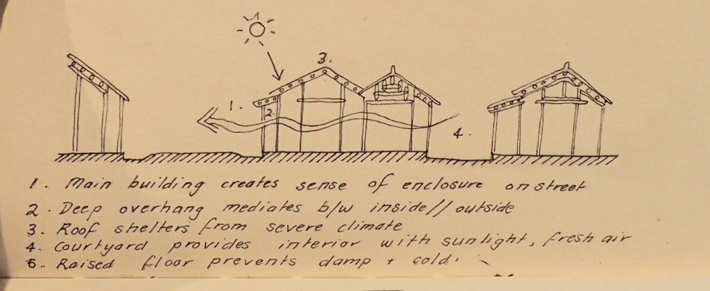
Housing type: Gurung house Location: Annapurna region Climate: Warm temperate climate / Subtropical Highland ( Koeppen classification Cwb) Siting and orientation Gurung houses generally form a scattered settlement plan, sprawled along terraced sloped adjacent to each family's fields. The long facade usually faces South, towards the sun. Plan and internal layout Gurung houses are rectangular in plan and typically 1.5 storeys high. At the front of the house is a porch, known as a 'pidi'. The Ground floor comprises of a multipurpose living space, housing kitchen, bedrooms, and store. A flight of stairs leads to the upper floor which is is generally used for extra bedding and storage. Walls Gurung houses are typically constructed from locally available stone, with clay and earth used as mortar. The stone is roughly dressed, forming a random rubble masonry pattern. The walls can be up to 500mm thick, providing high thermal mass. The interior is usually plastered with white or ochre mud. Roofs The pitched roof is supported by a timber structure bearing on the masonry walls. The roof is usually covered with large overlapping stone/slate tiles, though some newer houses have corrugated iron roofs. These roofs have large overhanging eaves that are supported by timber brackets. Outbuildings Temporary buildings used for storage and animal housing are of rough timber/ bamboo framed construction with woven bamboo thatch cladding. We recently completed the Annapurna Base camp trek, hiking through the stunning Himalayan landscapes of the Annapurna ranges and encountering the Gurung villages of the hill country along the way . It's a very relaxed trek in terms of the amount of gear you need to carry as there are tea houses spaced every few hours along the trail providing you with all the necessities such as food and accommodation. As we were hiking in the shoulder season, it was fairly quiet-some days we spent several hours walking without encountering anyone else, and for the first few nights we were the sole occupants staying at our guest houses. Day One: Khande to Landruk We began our trek in the town of Khande with a series of very steep stone steps. Barely 10 minutes into the trek I started to reconsider the decision to go on a nine day hike, considering the fact that the extent of my training consisted of about five training runs in the weeks leading up to it. After about 45 minutes we arrived at Australia Camp to have breakfast, where we were enticed with views of the Annapurna ranges hinting at the journey to come. Eventually the steep steps blissfully gave way to gentler uphill slope walking through shaded forest. We passed through the Gurung villages of Pothana and Tolka along the way before arriving early afternoon at Landruk, our destination for the night. Day Two: Landruk to Chomrong The day began with a steep descent from the village down to the river, then a gentler walk following beside the river. We crossed at 'New Bridge', and had a gentle uphill stretch before another steep descent down to the river, almost veering off the track and down an avalanche ( the path wasn't very well marked!). We stopped at the river for a lunch of chappattis and peanut butter. Little did we know what was in store for us next. It was an extremely steep ascent up thousands of stone steps to get to the town of Jhinu, and by then I was completely exhausted. Unfortunately we still had a way to go up several hundred more stone steps before we arrived at that nights destination, Chomrong. By the time we arrived at our guesthouse I could barely stand, my legs were like jelly. The pain dissipated somewhat when we saw the incredible view from our guesthouse, Annapurna and Machhapucchre towering before us. Day Three: Chomrong to Dhovan We lost most of our altitude in the morning with a steep descent down to the river. My calves were burning even worse than my thighs had been the day before when we going uphill. As I was pondering whether it was steep uphill or downhill that I loathed the most, we passed several groups of local children on their way up to school, leaving me to conclude that I had no grounds to complain about either. We crossed the suspension bridge at the edge of the town, ascending into the valley with views of Macchapucchre. The uphill stretch felt like a breeze compared to the previous days walking, and then we were faced with an easy downhill stretch to the town of Bamboo. We stopped for a picnic lunch by the river. From here it was a steep climb up to Dobhan, but nowhere near as bad as we had anticipated (the map had indicated 'very steep' steps). We arrived in Dobhan around 3:00pm with stunning, clear views out to Machhapucchre. I had been relaxing at the guesthouse when Bede came to the door breathlessly saying 'Want to see some monkeys!?'. He lead me five minutes down the path and pointed to a spot across the river. I peered through the monocular and sure enough there was a whole group of large white monkeys swinging through the trees. Day Four: Dhovan to Deurali We were greeted in the morning with a gentle uphill walk through forest with wildflowers blanketing each side of the path. As we approached the top of the ridge the going got steeper until eventually we could see glimpses of Deurali. Despite seeming quite close, it took us about another hour to reach the village. Passing through the valley we were in awe of mountains soaring either side of us and fantastic views of Machapucchre. We arrived just in time for lunch. Day Five: Deurali to Machapucchre Base Camp (MBC) We continued to make our way uphill through the valley along the river. Folded mountains either side of us gave way to tundra and grasslands, with patches of snow and ice along the way. We arrived at MBC around 2:00 and sat down for lunch and a pot of tea. After lunch we decided to walk partway up to ABC to do some exploring. We were rewarded by 360 degree mountain views. While we were perched on a boulder, taking it all in, a massive Steppe eagle soared overhead, both of us in complete awe of its size. After seeing incredible views like these, it's hard to imagine that ABC could improve on this. At this altitude the sun begins to fall by 3:00pm, and the clouds set in-both obscuring the view and causing it to become much colder. During the night it got down to around -10, so we were thankful for our down jackets and the sleeping bags we had hired. Altitude sickness also becomes a much bigger issue the higher you go, as the oxygen in the air decreases exponentially. The day before we met a couple on their way back to Deurali who told us a Korean man had died of altitude sickness that morning at MBC. It seems as though there are a lot of people have hiking this trail that are neither prepared for the conditions or aware of the effects of AMS. Day Six: Annapurna Base Camp to Dhovan We left early in the morning to ensure we had unobscured views and enough time to head all the way back to Dhovan before dark. It took about an hour and a half to reach ABC from MBC. The path was mainly covered in ice and snow so I was glad that I had brought some crampons with me. When we reached the camp we were overwhelmed by the feeling that we were completely surrounded by massive peaks. It is probably the most I incredible place I have ever been. Sitting amongst the prayer flags at 4130 metres, standing next to the likes of Annapurna 1 and Machapucchre feels almost as though you're on top of the world. A few days before as we passed through Bamboo, we came across a group of people carrying skis who told us they were working for an NGO teaching Nepalis how to ski. While we sat down for a cup of tea at ABC we were entertained by the sight of beginners learning to ski at what is perhaps one of the most unlikely and beautiful skiing locations in the world. Day Seven : Dhovan to Chomrong Most of the the way back to Chomrong was steady downhill with some steep sections. The whole time I had the thought in the back of my mind that we were going to have to climb up the thousands of steps we had descended on the way down from Chomrong. The expectation didn't make it any easier. By the time we made it into town I was basically crawling. For some reason Chomrong has an abundance of 'German bakeries', so despite our weariness; curiosity and a craving for chocolate cake sent us back down the slope in search of baked goods. For some reason, most of the shops were unattended or out of pastries so we settled on the one shop we actually found that was occupied. Our efforts were unfortunately in vain, as we were confronted with the most stale chocolate croissants I have ever tasted. The lesson? When you see a German Bakery sign while hiking in the Annapurna ranges don't trust it- it might as well be a mirage. Day Eight: Chomrong to Ghandruk From Chomrong we decided we would take a slightly different way down so that we could spend our last day in the Gurung village of Ghandruk. We thought we had taken the 'easier' local route down to the river, but as the path kept gaining altitude rather than sloping down we realised we had made a terrible mistake. After gaining several hundred metres unnecessarily, the path sloped sharply down to the river. We were then faced with a daunting uphill climb to the saddle which signified the path to Ghandruk. It took us several hours of climbing at a snail's pace before we reached the saddle. Thankfully there was a village at the top where we were able to have lunch and recoup before continuing on to Ghandruk. From here it was an easy downhill walk to Ghandruk. The village of Ghandruk sits sprawled across terraced fields, against the backdrop of the Himalayas. I spent the afternoon walking through the steep, narrow streets and exploring the traditional houses of the Gurung people. Day Nine: Ghandruk to Pokhara From Ghandruk we walked along the road to the town of Kimche, where we caught the bus back to Pokhara. Housing type: Newari house
Location: Bhaktapur, Kathmandu valley Climate: Warm temperate climate / Subtropical Highland ( Koeppen classification Cwb) Siting and orientation Newari houses form a dense settlement pattern consisting of rows of several houses situated around courtyards. One of the houses along the street usually has a small doorway called a 'galli ' that enters into the courtyard. These courtyards allow for greater solar penetration into the homes as well as providing a warm, central, private space for family activities such as clothes washing and bathing. The long (front) facade is generally South facing, towards the sun. Plan and internal layout Newari houses are rectangular in plan and typically 3-4 storeys high. Up until the 16th century, Newari houses were not permitted to exceed the height of nearby temples, thus they have quite a low ceiling height of 1.6-1.9 metres. This low ceiling height allows the rooms to be heated more easily during winter. The ground floor was traditionally reserved as the entry and storage space, providing a buffer between the cold and humid ground and the first floor. In Bhaktapur, many houses now use their ground floor as a shop front. The first floor consists of bedrooms while the second floor houses the main living area. These areas both receive enough solar radiation to heat the rooms during the day. The third floor attic ( known as 'Buigya' ) has a kitchen with open fireplace. By placing the kitchen at the top of the house, the bedroom and living areas are prevented from overheating in the Summer. The Buigya also has a trap door at the end of the stairs that leads to the roof. The semi-enclosed courtyard provides an important space to carry out daily tasks and family activities. It is designed so that it keeps shaded in the summer, while providing a warm space in the winter. Walls The walls of Newari houses are constructed from sun dried or burnt clay bricks and between 30-70cm thickness. This thickness provides high thermal mass. Roofs The roofs are pitched, with a large overhang to shade the house from solar radiation in summer and protect from heavy rains during the monsoon season. Clay roof tiles are supported by a timber structure. Foundation, floors, ceiling Most houses sit atop a 60-80cm stone plinth to protect against monsoonal flooding. The floors and ceilings consist of a timber framework covered by lathe work supporting a rough cast layer of mud. The use of clay and earth provides thermal mass to the floor and assists in balancing diurnal temperature changes. Openings The majority of windows are located in the long facade of the house, oriented South. The main living area has a large window called a 'Sajhyas' with decorative wood carvings. The position of this window allows lower angle sun to heat the room in winter. Most of the windows have grilles to protect from summer sun and shutters which can be opened/ closed depending on the conditions. The large roof overhang shades the southern facade and windows, in addition to protecting from monsoon conditions. |
AuthorMichi Playford - 4th Year Master of Architecture student at The University of Newcastle 
ArchivesCategories |
 RSS Feed
